RSS 5 Day Weather Outlook
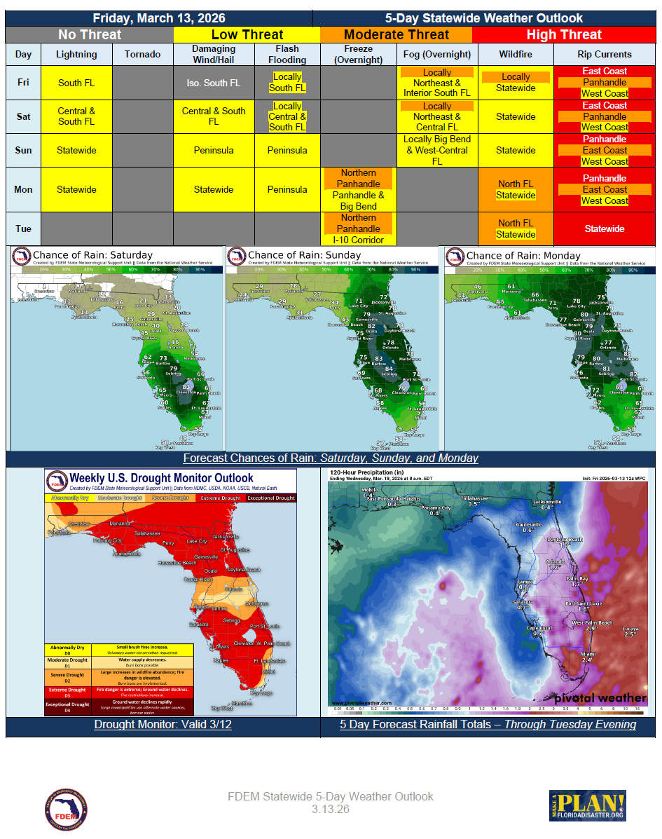
5 Day Statewide Weather Outlook for Fri. 3/13 to Tue. 3/17
You are subscribed to 5 Day Weather Outlook for Florida Division of Emergency Management. This information has recently been updated, and is now available.
… Active Weekend Expected with Daily Shower and Thunderstorm Activity Across the Peninsula… South Florida the Focus on Friday and Saturday, Expanding to Include the Entire Peninsula Sunday… Locally Strong to Severe Storms Possible… Locally Heavy Downpours May Bring Urban Flooding Concerns… Next Potent Cold Front Arrives Monday with Showers and Thunderstorms Statewide… Much Cooler Air Filters into North Florida in the Wake… Local Frost or Freezes Possible Along the I-10 Corridor… High Risk for Rip Currents Remains for Numerous Florida Beaches Through the Forecast Period…
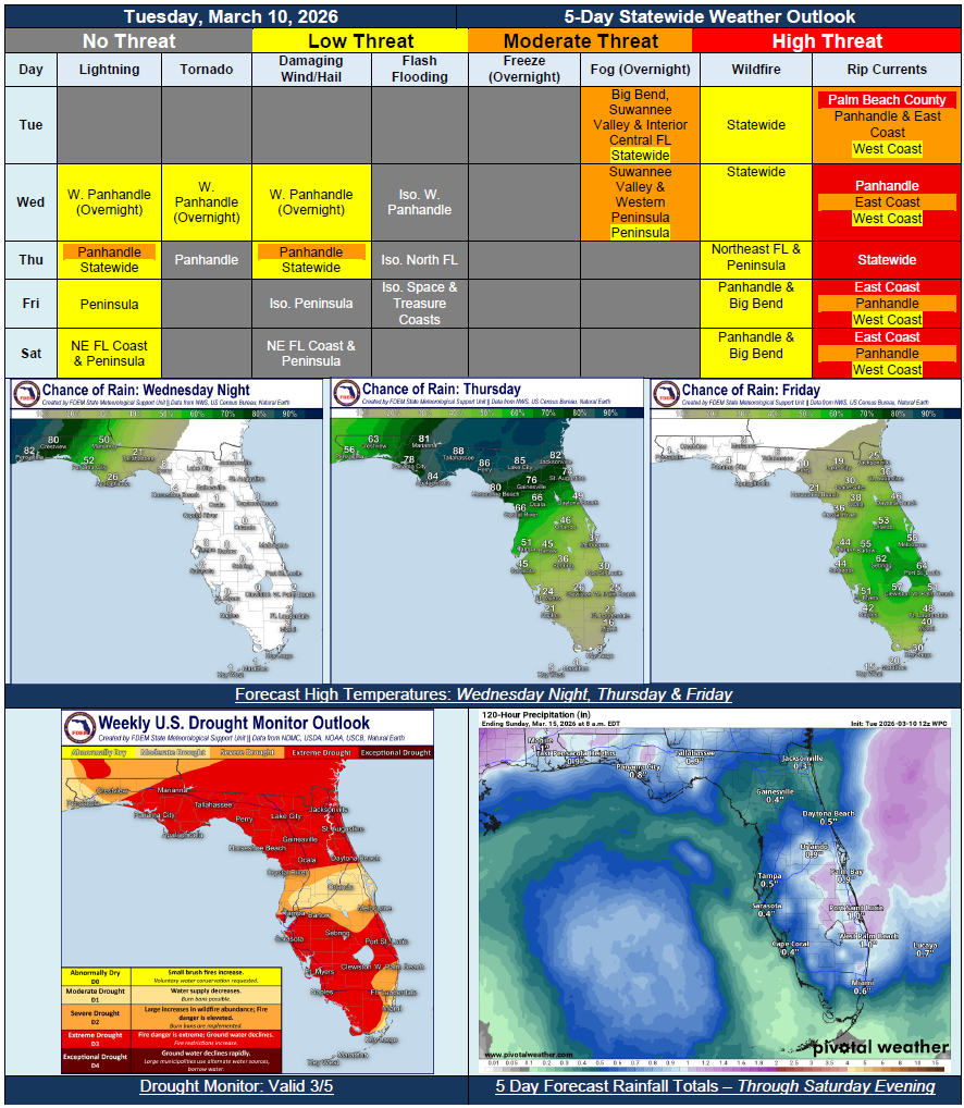
5 Day Statewide Weather Outlook for Tue. 3/10 to Sat. 3/14
You are subscribed to 5 Day Weather Outlook for Florida Division of Emergency Management. This information has recently been updated, and is now available.
…Foggy Mornings Through Midweek…Dry Conditions and Above Seasonal Normal Temperatures to Start Off the Forecast Period…Cold Front Moving In Wednesday Night and Thursday to Bring Rounds of Showers and Thunderstorms…Embedded Strong to Severe Thunderstorms Possible for the Panhandle Early Thursday Morning…Cooler Temperatures Near Seasonal Normals Expected At the End of the Week…Shower and Embedded Thunderstorm Activity to Continue Across the Peninsula Through the Weekend…
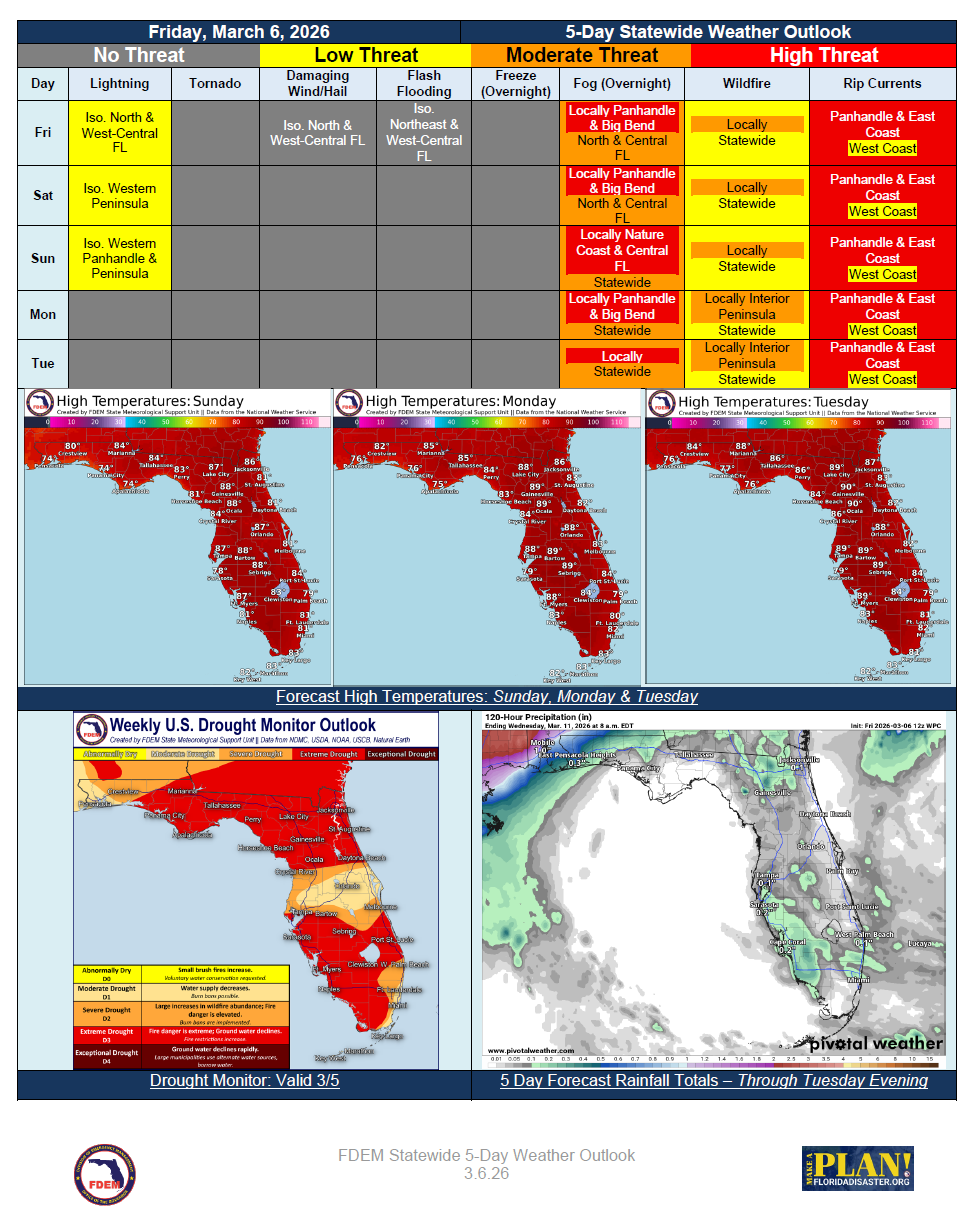
5 Day Statewide Weather Outlook for Fri. 3/6 to Tue. 3/10
You are subscribed to 5 Day Weather Outlook for Florida Division of Emergency Management. This information has recently been updated, and is now available.
…Summer-like Conditions to Persist Through the Forecast Period Across the Sunshine State… Locally Dense Fog to Remain a Hazard Each Morning Across North and Central Florida… Sea Breezes to Promote Isolated Showers and Embedded Thunderstorms This Weekend… Near-Record Warmth Expected in Most Locations… Breezy Onshore Winds Keep a High Risk for Rip Currents at all Panhandle and East Coast Beaches… Extreme Drought (Level 3 of 4) Now Covers 70% of the State…
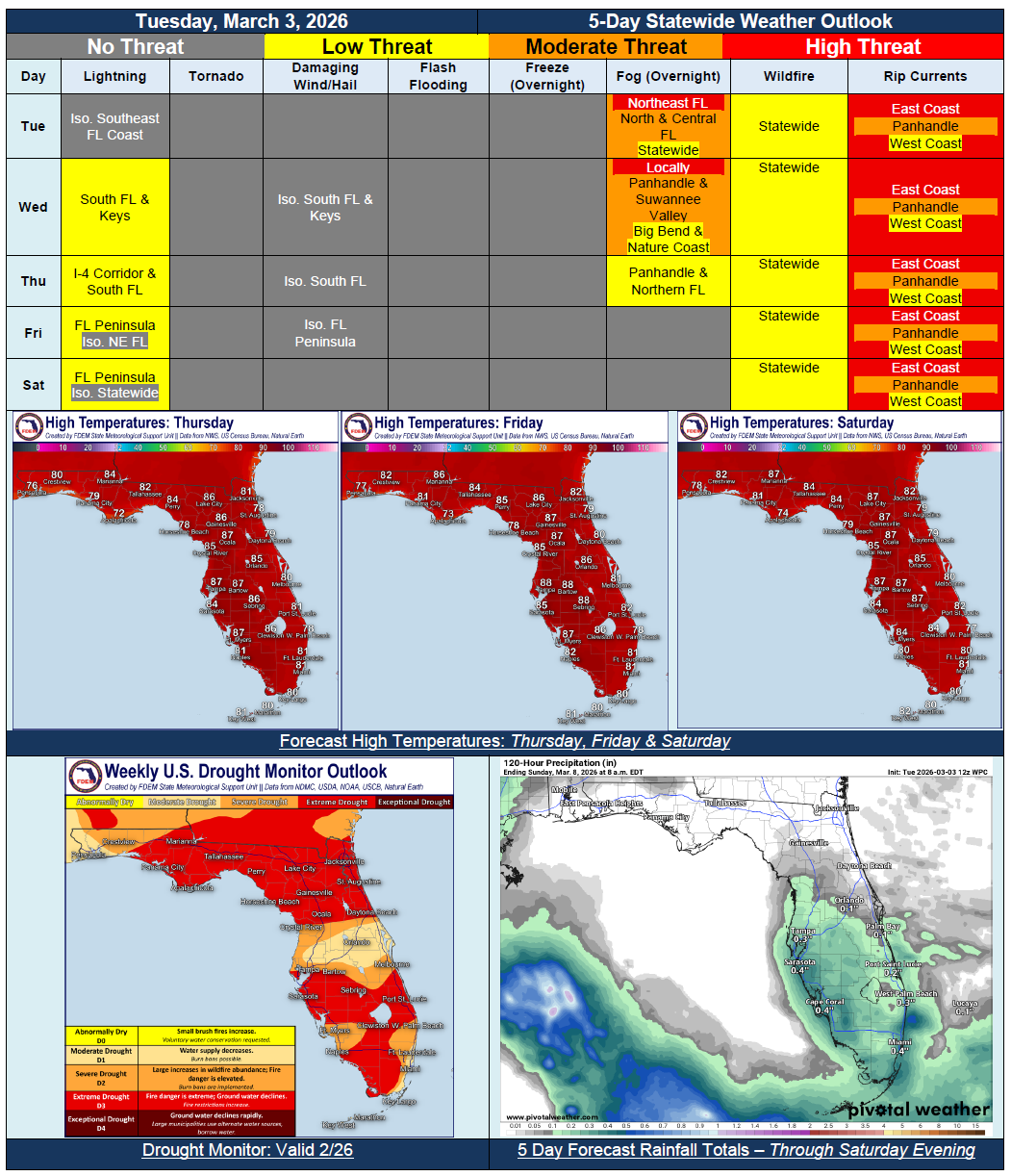
5 Day Statewide Weather Outlook for Tue. 3/3 to Sat. 3/7
You are subscribed to 5 Day Weather Outlook for Florida Division of Emergency Management. This information has recently been updated, and is now available.
…Spring and Summer-Like Conditions Expected This Week…Above Normal Temperatures With Possible Record-Breaking High Temperatures…Return of Brief Afternoon Showers and Possible Thunderstorm or Two…Instances of Fog at Night and Early in the Mornings…Sensitive Wildfire Conditions Persist with Ongoing Drought Conditions…High Risk for Rip Currents for All East Coast Beaches this Week…
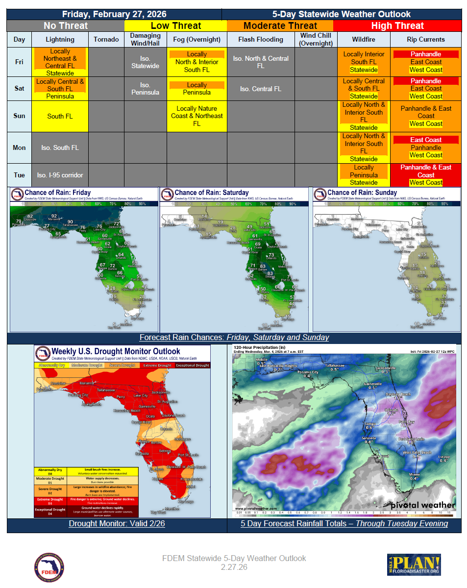
5 Day Statewide Weather Outlook for Fri. 2/27 to Tue. 3/3
You are subscribed to 5 Day Weather Outlook for Florida Division of Emergency Management. This information has recently been updated, and is now available.
…Slow-Moving Frontal System to Bring Rounds of Scattered Showers and Thunderstorms to the State Beginning Today… Locally Strong Thunderstorm Activity Cannot be Ruled Out Across the Peninsula Today and Saturday… Beneficial Rainfall to Mitigate Larger Wildfire Risk, though Pockets of Locally Elevated Conditions Persist Through Forecast Period… Mostly Dry Conditions Return to the State Monday and Tuesday… Warm Temperatures to Remain a Theme Through Early Next Week… No Changes in Latest Drought Monitor this Week; Severe to Extreme Drought Persist…